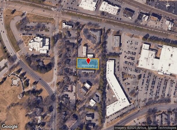
Property Record
641 Oakleaf Office Ln, Memphis, TN 38117
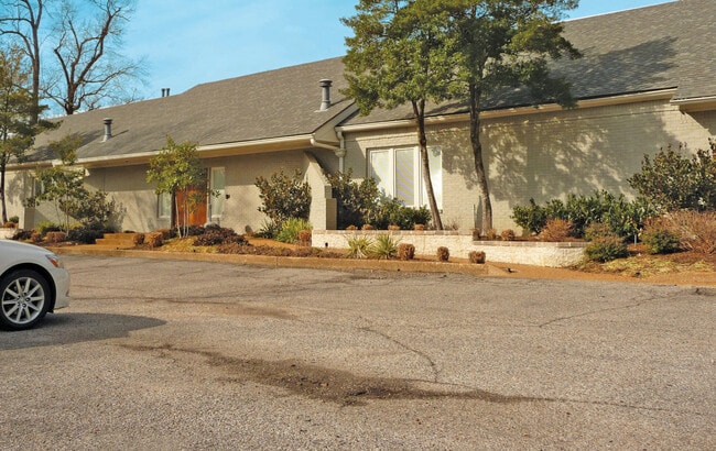
This Property Is For Sale
NEARBY LISTINGS FOR SALE OR LEASE
Property Detail
641 Oakleaf Office Ln
Memphis, TN-MS-AR
Oakleaf Office Lane Gen Plan P.U.D.
06-5010-B0-0004
WS OAKLEAF OFFICE LN P.D.
Officebuilding
Shelby
X
Tennessee
47157C0435F
9
2024
0.60 AC
2025
East
009300
Memphis
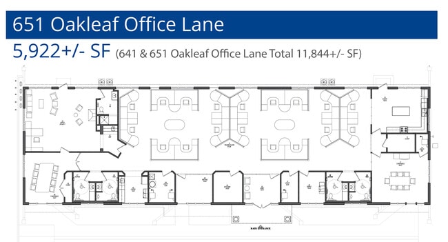
5,922 SF
DEMOGRAPHICS near 641 Oakleaf Office Ln
1 Mile
3 Mile
5 Mile
2024 Total Population
6,058
81,933
233,315
2029 Population
5,898
80,496
231,287
Pop Growth 2024-2029
(2.64%)
(1.75%)
(0.87%)
Average Age
44
38
37
2024 Total Households
2,925
35,094
93,910
HH Growth 2024-2029
(2.80%)
(1.89%)
(1.00%)
Median Household Inc
$87,607
$62,553
$48,471
Avg Household Size
2.10
2.30
2.40
2024 Avg HH Vehicles
2.00
2.00
2.00
Median Home Value
$371,254
$266,917
$205,706
Median Year Built
1959
1958
1964
Nearby Places
- Restaurants
- Banks
- Shops
- Fitness
- Groceries
PUBLIC TRANSPORTATION
COMMUTER RAIL
Central Station (Riverfront Loop - Memphis Area Transit Authority Trolley (MataTrolley))
DRIVE
WALK
Distance
Central Station (Riverfront Loop - Memphis Area Transit Authority Trolley (MataTrolley))
19 min
9.9 mi
AIRPORT
Memphis International
DRIVE
WALK
Distance
Memphis International
16 min
10.0 mi
Nearby Properties
Address
Land Use
TOTAL SIZE
Lot Size
Zoning
Address
Land Use
TOTAL SIZE
Lot Size
Zoning
1,082,619 SF
34.67 AC
CMP-1
Address
Land Use
TOTAL SIZE
Lot Size
Zoning
218,327 SF
4.89 AC
R-6
Address
Land Use
TOTAL SIZE
Lot Size
Zoning
189,536 SF
49.14 AC
CMU-2
Address
Land Use
TOTAL SIZE
Lot Size
Zoning
85,062 SF
8.43 AC
CA
Address
Land Use
TOTAL SIZE
Lot Size
Zoning
104,337 SF
7.30 AC
R-15
Address
Land Use
TOTAL SIZE
Lot Size
Zoning
101,654 SF
6.61 AC
R-15
Address
Land Use
TOTAL SIZE
Lot Size
Zoning
286,167 SF
18.91 AC
R-10
Address
Land Use
TOTAL SIZE
Lot Size
Zoning
657,276 SF
10.18 AC
OG
Address
Land Use
TOTAL SIZE
Lot Size
Zoning
190,263 SF
6.59 AC
R-10
Address
Land Use
TOTAL SIZE
Lot Size
Zoning
2,505 SF
52.59 AC
R-10
Address
Land Use
TOTAL SIZE
Lot Size
Zoning
45.85 AC
CA
Address
Land Use
TOTAL SIZE
Lot Size
Zoning
118,073 SF
4.75 AC
CMU-1
Address
Land Use
TOTAL SIZE
Lot Size
Zoning
24.72 AC
R-10
Address
Land Use
TOTAL SIZE
Lot Size
Zoning
114,326 SF
1.99 AC
R-6
Address
Land Use
TOTAL SIZE
Lot Size
Zoning
109,774 SF
8.80 AC
CMU-1
Address
Land Use
TOTAL SIZE
Lot Size
Zoning
66,067 SF
3.01 AC
CMU-3
Address
Land Use
TOTAL SIZE
Lot Size
Zoning
145,980 SF
16.50 AC
RU-3
Address
Land Use
TOTAL SIZE
Lot Size
Zoning
113,826 SF
29.01 AC
RU-3
Address
Land Use
TOTAL SIZE
Lot Size
Zoning
96,768 SF
7.98 AC
OG
Address
Land Use
TOTAL SIZE
Lot Size
Zoning
130,111 SF
5.95 AC
R-15
Address
Land Use
TOTAL SIZE
Lot Size
Zoning
71,673 SF
1.49 AC
OG
Address
Land Use
TOTAL SIZE
Lot Size
Zoning
104.22 AC
R-15
Address
Land Use
TOTAL SIZE
Lot Size
Zoning
109,308 SF
7.13 AC
OG
Address
Land Use
TOTAL SIZE
Lot Size
Zoning
206,186 SF
13.64 AC
CMU-2
Address
Land Use
TOTAL SIZE
Lot Size
Zoning
116,745 SF
10.46 AC
CA
Address
Land Use
TOTAL SIZE
Lot Size
Zoning
123,976 SF
10.31 AC
CMU-3
Address
Land Use
TOTAL SIZE
Lot Size
Zoning
103,252 SF
4.55 AC
OG
Address
Land Use
TOTAL SIZE
Lot Size
Zoning
87,283 SF
2.14 AC
CMU-1
Address
Land Use
TOTAL SIZE
Lot Size
Zoning
162,614 SF
3.31 AC
OG
Address
Land Use
TOTAL SIZE
Lot Size
Zoning
91,890 SF
10.36 AC
R-15
The World's #1 Commercial Real Estate Marketplace
Connect with us
© 2025 CoStar Group
The information above has been obtained from sources believed reliable. While we do not doubt its accuracy we have not verified it and make no guarantee, warranty or representation about it. It is your responsibility to independently confirm its accuracy and completeness. Any projections, opinions, assumptions, or estimates used are for example only and do not represent the current or future performance of the property. The value of this transaction to you depends on tax and other factors which should be evaluated by your tax, financial, and legal advisors. You and your advisors should conduct a careful, independent investigation of the property to determine to your satisfaction the suitability of the property for your needs.